by Richard Parsons
The Sanborn maps are a special resource for historians and other preservation-minded people. They were created by an independent company. The maps charted pretty much everything in built-up urban areas, so that insurance companies could determine what the fire risk was for any property they insured. The maps are drawn at a scale of 50 feet to the inch, which makes them very detailed. They are coded to show whether buildings have flammable or fire-proof roofs, and whether they are frame or masonry. They show where the fire hydrants and cisterns are.
The Sanborns are available online through the Library of Congress. The earliest New Bern Sanborn map is 1885; the latest at the Library of Congress is 1924. They are an invaluable aid to determine the age of buildings likely to have been built in the area covered. A good example is garages, which were discussed here earlier. A good example is the partial brick walls behind the Slover house. They are the right size to hold automobiles, they are not present on the 1913 map but present on the 1924 map. Clearly they represent an early garage.
The earliest map only covers the intense commercial area along the waterfront and Middle and Craven Streets to Pollock Street. The 1924 map reflects the growth of New Bern, stretching west to First Street, plus a good section of Ghent out to Seventh Avenue, northwest to Biddle Street/C street and encompassing all of Riverside to North Street. What is now called Duffyfield was, in 1924, divided into Pavietown, Larksville, and Mechanicsville.
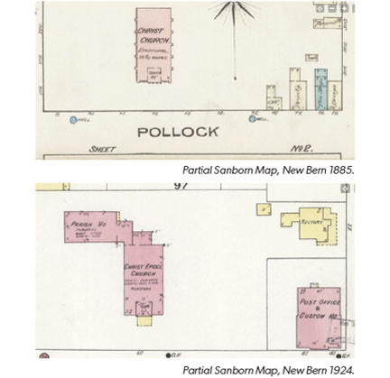
The two illustrations show the area of Christ Church in 1885 and in 1924. In 1885 we see the church standing in solitary splendor; the map indicates that it is 28 feet to the eaves and there is an 85 foot tower. There are a few small buildings on the corner; City Hall had not been built. Pink is brick construction, blue is stone, and yellow is frame.
In 1924, we see the same area. A brick parish house has been built on the NW corner of the church. The City Hall (Post Office and Custom House) occupies the corner. North of it is the frame rectory.
If you are inspired to see more, just Google <Sanborn Maps New Bern>
New Bern Preservation Foundation, Inc.
www.newbernpf.org • info@newbernpf.org • 252.633.6448

